Drone flyovers: document expansive land art and wow online recruiters
Drone flyovers turn a field-sized artwork into a thirty-second pitch even busy recruiters finish. Follow this guide to plan, film, edit, and publish aerial footage that unlocks bigger briefs, faster.
Why drone flyovers boost land-art visibility
Reveal scale at a glance
A recruiter often decides in under ten seconds whether your installation fits the brief. Drone flyovers capture footprint, topography, and spectator flow in one smooth shot—something still photos rarely achieve.
Deliver data that underpins budgets
Altitude footage lets you overlay dimensions, visitor counts, or biodiversity metrics. Pair the clip with the impact metrics for land art framework and you hand decision-makers every figure they need.
Rank higher in directory search
Many talent platforms give extra weight to video profiles. Drone flyovers tagged with coordinates align perfectly with geo-tag tactics and push your listing toward the top results.
Source : Wistia Video Index
Pre-flight checklist: prep your artwork and permissions
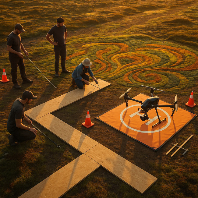
From clearing the nearest treeline for satellite connectivity to lining plywood strips across mossy surfaces, the ground team spends nearly an hour preparing the site before the first rotor even spins. They measure magnetic interference, mark 3×3-meter safety boxes in chalk, brief wildlife wardens on noise windows, and rehearse emergency hand signals. These backstage logistics rarely make flashy highlight reels, yet recruiters who manage six-figure budgets notice when they are missing: your clip's polish is proof of disciplined stewardship.
- Secure permits early. Local aviation rules differ. Cross-check flight zones alongside the permit pathways guide.
- Mark take-off and landing pads. A 3×3 m clear zone prevents dust storms that could stain pigments or living plants.
- Brief your ground crew. They monitor battery swaps, crowd distance, and unforeseen wildlife intrusions.
- Protect delicate surfaces. Use plywood walkways for operators to avoid footprint damage before take-off.
- Schedule around golden hour. Low sun angles emphasise contour depth. Capture shadows, then a midday pass for clean colour.
Flight planning that sells the story
Think storyboard first, rotor speed second. Sketch three sequences:
- Reveal: Start tight on a texture—moss, gravel, or recycled glass—then ascend to 50 m for the big reveal.
- Orbit: Circle the centrepiece at constant altitude. Use waypoints to keep pacing smooth.
- Context: Finish with a pullback to show how the art integrates with surrounding farms, rivers, or skylines.
Add GPS tags to each waypoint. It speeds up editing and aligns with recruiters' need for precise locations when browsing land-art specialist listings.
Optimal technical specs
| Parameter | Recommendation | Why it convinces recruiters |
|---|---|---|
| Resolution | 4K UHD, 25 fps | Future-proof for large screens and TV spots |
| Colour profile | D-Log or Cinelike | Allows flexible grading to match brand palettes |
| Bitrate | >100 Mbps | Maintains texture detail during pans |
| Shutter speed | 1/50 s | Natural motion blur; avoids choppy frames |
| Lens filter | ND16–64 | Controls highlights in reflective materials |
Editing secrets: turn raw clips into a magnetic reel
Keep it under 45 seconds
Analytics show recruiter drop-off spikes after the 48-second mark. Trim ruthlessly. Lead with your strongest reveal, then layer quick lower-third captions: area, materials, timeframe.
Add spatial overlays
Motion-tracked arrows guide the eye along paths. Recruiters understand circulation flow instantly—crucial for public-safety approvals.
Subtle sound design
Blend natural ambience with light music. Field recordings of wind or birds maintain authenticity and differentiate you from stock footage.
Publishing and distribution
Embed on talent directories first
Many directories autoplay muted video. Upload an MP4 under 50 MB to stay within most platform caps. Pair the post with high-res site maps—see land-art site maps for template ideas.
Optimise social snippets
Crop a 9:16 teaser for Reels or TikTok. Add a CTA pointing back to the full flyover on your profile.
Archive master files
Store ProRes originals in cloud drives with metadata: flight ID, altitude, and weather. Future sponsors may request alternative edits.
Case study workflow
Combine your drone clip with on-ground interviews, soil testing visuals, and budget breakdowns. Recruiters see creativity, logistics, and sustainability in one bundle—often the tipping point for closed deals.
Common pitfalls and proven fixes
- Wind distortion. Schedule backup days and carry polarised filters.
- Patchy GPS. Cache maps offline and set manual exposure presets.
- Audience shadows. Rope off viewing zones outside flight paths.
Quiz: Are you flyover-ready?
FAQ
- Do I need a commercial pilot licence for drone flyovers?
- Most countries require a basic certificate for paid shoots. Check local aviation bodies and secure insurance before flying.
- What drone model should I start with?
- A foldable drone with a 1-inch sensor and manual exposure controls is enough. Upgrade once clients request 5.1K delivery.
- How do I protect wildlife on site?
- Fly above 30 m, limit noise time to ten minutes per pass, and brief a spotter to monitor animal behaviour.
- Can I monetise raw aerial footage?
- Yes. Offer stock clips to environmental agencies or layer them into VR tours for additional revenue.
Take the next step
Ready to make drone flyovers part of your standard proposal? Combine today's checklist with seasonal site scouting insights and deliver installations recruiters cannot ignore.
Action now: Block one afternoon this week, storyboard your first 45-second flyover, and book a certified pilot. Your next big commission could hinge on that single aerial reveal.