Drone vs ground cameras: choose the landscape angle that elevates your narrative
Wondering whether drone vs ground cameras will give your landscape story the edge? This guide compares altitude, mood, cost, and legalities so you can pick— or combine—the right viewpoint and wow clients every time.
Why angle matters in landscape storytelling
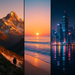
Landscape photography is more than showing a place; it shapes how viewers feel about that place. A soaring aerial panorama suggests scale and freedom, while a low-angle ground shot can convey texture, intimacy, or even vulnerability. Choosing between drone vs ground cameras influences narrative tone, brand positioning, and conversion rates on project bids. For agencies pitching eco-tourism or real-estate developments, the chosen angle can raise perceived property value by double-digit percentages, according to recent market studies, while documentary filmmakers report stronger emotional retention when sequences alternate between sweeping context and tactile detail. The science behind this lies in visual hierarchy: humans process broad spatial data first, then drill down into minutiae, so guiding the audience through both perspectives keeps dopamine and curiosity levels high. Understanding this psychological trigger can therefore sharpen your competitive edge during proposal reviews and client negotiations.
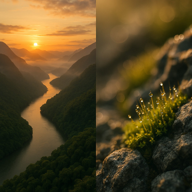
When drones steal the show
Signature strengths of aerial imagery
- Sweeping context – Reveal river bends, road patterns, or architectural symmetry invisible from eye level.
- Dynamic motion paths – Programmable flight lets you create reveal shots that ground sliders can't emulate.
- Data layering – Pair footage with GIS and drone mapping tips to add measurable metrics for eco or infrastructure briefs.
- Client engagement – The National Association of Realtors reports 70 % higher listing clicks on properties with drone footage.
Hidden constraints to factor in
Despite the buzz, drones have limits. Battery life averages 25–34 minutes, wind tolerance caps at 10 m/s for prosumer models, and most regions enforce a 120 m ceiling. You'll need permits, insurance, plus certified pilots for commercial shoots. Check local rules alongside 2025 drone regulations.
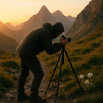
The enduring value of ground cameras
Ground-level superpowers
- Tactile detail – Macro lenses capture moss, bark, or human elements that add scale.
- Low-light mastery – Full-frame sensors, ND filters, and tripods beat drones after sunset.
- Creative intimacy – Ground rigs foster emotional connection, ideal for storytelling campaigns that combine portrait and landscape themes.
- Smaller carbon footprint – No batteries to charge mid-shoot, fewer take-offs mean lower emissions.
Ground-level drawbacks
You may need ladders, cranes, or helicopters for altitude. Terrain can obstruct lines of sight, and the wow-factor suffers when stakeholders expect “the drone look.” Yet, the classic tripod shot rarely suffers from no-fly rules or signal interference.
Decision matrix: match the angle with the message
| Project goal | Best primary tool | Why it wins | Complementary angle |
|---|---|---|---|
| Show vast scale (nature reserve, solar farm) | Drone | 120 m vantage reveals boundaries | Ground close-ups of flora for texture |
| Highlight craftsmanship (vineyard, sculpture garden) | Ground camera | Shallow depth of field flatters detail | Low-altitude drone orbit at golden hour |
| Data-driven proposal (infrastructure, land art) | Drone + GIS overlay | Top-down accuracy for area metrics | Handheld interviews for human context |
| Social-media teaser | Drone | 15-second reveals boost CTR | Smartphone B-roll for authenticity |
| Long-form documentary | Ground camera | Stable rigs allow extended interviews | Timed drone flyovers between scenes |
Source : National Association of Realtors
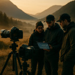
Workflow tips for hybrid shoots
Client briefs rarely pick sides in the drone vs ground cameras debate—they crave both. Use these tactics to streamline production:
- Storyboard altitude moments first; every battery swap adds downtime.
- Sync color profiles (D-Log, S-Log) so grading looks seamless.
- Location scout twice: once on foot, once via virtual waypoint planning in apps like DJI FlightHub.
- File-naming conventions – prefix “DRN_” or “GRD_” to keep editors sane.
- Rights & credits – clarify pilot licensing and camera-op roles in contracts to avoid disputes.
For more advanced flight-to-edit pipelines, check our guide on drone workflows for architecture shoots.
Pitching visuals that win briefs
Include mixed-angle mood boards in your deck. Recruiters browsing the landscape photographer directory respond better to proposals that show both aerial scale and ground-level emotion. Pairing a drone hero shot with a tripod-steady texture frame communicates versatility and boosts shortlist rates.
If interactivity is a key selling point, embed interactive 360° landscape tours; buyers spend 40 % longer on pages offering immersive navigation.
Case spotlight: land-art documentation
Eco-art studios often juggle scale and detail. One team combined orbiting drones for footprint mapping with handheld gimbals for process shots. The result secured funding in week one. Learn their full method in this land-art drone flyover case study.
Quiz: are you framing the landscape at its best?
FAQ
- Do drones replace ground cameras entirely?
- No. Drones add scale, but ground rigs still excel in detail, low-light, and narrative intimacy.
- What insurance do I need for drone shoots?
- Commercial liability covering airspace regulations, plus hull coverage for the craft and payload.
- How can I match color across drone and DSLR footage?
- Shoot both in flat profiles (D-Log, S-Log), white-balance to the same Kelvin, and create a single LUT in post.
- Is it worth hiring a licensed pilot instead of flying myself?
- If local law demands certification or the project budget justifies risk reduction, hiring a pro saves fines and reshoots.
Conclusion: choose, combine, conquer
In the drone vs ground cameras debate, the real winner is the story. Drones deliver sweeping context; ground cameras build emotional depth. Master both, and your landscape narratives will convert browsers into buyers faster than ever.
Ready to elevate your next brief? Build a mixed-angle storyboard today and watch your proposal jump to the top of the shortlist.